
Unprecedented Duration and Impact
Cyclone Biparjoy has made its presence felt in the Arabian Sea for nearly ten days, emerging as one of the most impactful cyclones to hit India in recent decades. As it gathers moisture over time, the cyclone poses an increased risk of devastating floods and destructive winds upon landfall.
Swift Formation and Unexpected Intensification
Biparjoy’s transformation from a mere circulation to a Very Severe Cyclonic Storm within 48 hours has caught forecasters off guard. Its rapid intensification has surpassed that of previous cyclones, including Cyclone Mocha in May. The storm has further developed into an Extremely Severe Cyclonic Storm, displaying its unpredictable nature.
Factors Fueling the Cyclone Biparjoy’s Intensity
The exceptionally warm Arabian Sea, with temperatures exceeding 30°C, has played a crucial role in fueling Biparjoy’s rapid intensification. Additionally, favorable Madden-Julian Oscillation conditions in the Indian Ocean and the presence of Equatorial Rossby Waves in the Arabian Sea have contributed to the storm’s growth.
Uncertainty in Movement Projections
Initial forecasts for Biparjoy’s trajectory presented conflicting information. While NOAA’s GFS suggested a course towards Oman, the ECMWF hinted at movement towards Pakistan and the north Gujarat coasts. The India Meteorological Department’s GFS indicated an approach towards the Iran-Pakistan coasts. Ultimately, the cyclone has deviated from these projections, heading towards the northern Gujarat coast.
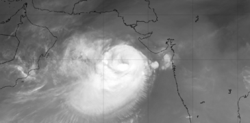
Current Location and Impending Landfall
According to the IMD, the Extremely Severe Cyclonic Storm Biparjoy is currently positioned in the east-central Arabian Sea, approximately 300 km away from the Gujarat coast. It is expected to move slightly eastward and make landfall near Jakhau Port in Gujarat by Thursday. With peak intensity recorded on Monday, featuring winds of 165-175 kmph, gusting to 195 kmph.
Anticipated Impact and Precautionary Measures
As Biparjoy approaches, heavy rainfall (64.5 mm – 115.5 mm) is forecasted for Saurashtra and Kutch regions in the coming days. Upon landfall in Gujarat, the cyclone may generate storm surges of 2-3 meters, leading to damage of houses, roads, crops, and disruption of transportation, power, and communication systems. It is crucial to take precautionary measures to ensure your safety and the well-being of your community.